The 7-Day Bhutan Itinerary: The Health-Smart Version

This 7-day Bhutan itinerary runs Paro to Thimphu to Punakha and back, finishing with the Tiger's Nest (Paro Taktsang) hike, a temple that sits at about 3,120 m (10,240 ft) per regional survey data. Most of the route sleeps below 2,400 m, so acute mountain sickness is uncommon, but the CDC notes AMS affects roughly 25% of travelers who sleep above 2,500 m, and the Dochula Pass and Tiger's Nest both cross above that line. The health-smart move is to use the early valley days to acclimatize, keep sleeping elevations low, and talk to a clinician about acetazolamide before you go. The CDC also recommends Hepatitis A and Typhoid for most travelers to Bhutan.
Bhutan rewards travelers who plan around its terrain instead of fighting it. The classic western circuit, Paro to Thimphu to Punakha and back to the Tiger's Nest, is not a hard trek, but it threads moderate altitude, a high mountain pass, and a strenuous final-day climb into one short week. As an ER physician, my framing is simple: use the early valley days to let your body adjust, keep your sleeping elevations low, and save the biggest effort for when you are acclimatized. Do that, and the health risks here stay small and manageable. This itinerary lays out the route day by day and shows where the altitude, the road, and the food and water actually shape the plan.
Who this itinerary is for
This is a strong first trip to the Himalaya for travelers who want culture and scenery without committing to a multi-day camping trek. You sleep in lodges and hotels every night, you visit high points rather than living at them, and the hardest single day, the Tiger's Nest, is a day hike you can pace to your own fitness. First-timers should expect moderate elevation, some winding mountain roads, and one genuinely strenuous climb.
Returning trekkers and altitude-experienced travelers can use the same skeleton and add harder limbs, such as the Druk Path trek or higher passes, where you would sleep above 3,500 m and the altitude math changes significantly. If you extend upward, treat the acclimatization and medication planning as non-negotiable rather than optional. Anyone with heart or lung conditions, or a prior history of altitude illness, should review this route with a clinician first.
The route
Bhutan's main tourist corridor runs west to east across a series of river valleys connected by mountain passes, and this loop covers the most accessible and scenic stretch of it. You start in Paro (around 2,200 m), home to the international airport and the Tiger's Nest, then move to the capital, Thimphu (around 2,334 m), about a 1.5-hour drive away. From Thimphu you cross the Dochula Pass at roughly 3,100 m, marked by its 108 Druk Wangyal chortens, and descend steeply into the warm Punakha valley (around 1,250 m), one of the lowest and most relaxed stops on the route.
The return retraces the same passes back to Paro, where you rest before the Tiger's Nest hike on the second-to-last day. The geography is the whole point for health planning: you gain and lose elevation repeatedly, but you deliberately sleep low while visiting high. That climb-high, sleep-low pattern is the single biggest reason this route is gentler on the body than a continuous Himalayan ascent. The total driving is modest, but the roads are winding, which matters more for motion-related nausea than for time.

Day-by-day plan
Day 1: Arrive Paro, settle at ~2,200 m
The flight into Paro is one of the most dramatic approaches in aviation, weaving between ridgelines to a valley-floor runway. Once you land, treat the rest of the day as acclimatization. Visit Rinpung Dzong and the National Museum, walk along the Paro Chhu river, and keep the pace easy. At 2,200 m most people feel only mild effects, if any, but hydration and a light first day set you up well. Skip alcohol tonight; it worsens both dehydration and sleep at altitude.
Day 2: Paro to Thimphu (~2,334 m)
A short, scenic drive brings you to Bhutan's capital. The giant Buddha Dordenma statue overlooks the valley, and the Memorial Chorten is a living center of daily worship. Thimphu is walkable and relaxed, with the world's only capital that runs without traffic lights. The elevation gain from Paro is small, but this is the point to start paying attention to your body. A nagging headache, nausea, or a poor night's sleep can be early acute mountain sickness, and noticing it now is easier than diagnosing it on a hard hiking day.
Day 3: Thimphu acclimatization hike
Spend today building altitude tolerance the right way. A hike toward Cheri or Tango monastery takes you up to roughly 2,800 to 3,000 m through blue-pine forest, and then you come back down to sleep in Thimphu. This climb-high, sleep-low rhythm is exactly what the CDC's altitude guidance encourages: gradual exposure with conservative sleeping elevations. It also previews the kind of sustained uphill effort you will need on the Tiger's Nest. If you feel strong here, that is a good signal for the climb to come.
Want the health prep for Bhutan?
Get a 60-second pre-trip check: the vaccines, prescriptions, and altitude/seasonality notes that change the plan — built for your exact dates.
Day 4: Thimphu to Punakha over Dochula Pass (~3,100 m)
Today you cross the highest road point of the trip. The Dochula Pass, at about 3,100 m, is crowned by 108 chortens and, on clear mornings, a wall of Himalayan peaks. You only pause here; you do not sleep at this elevation. From the pass the road drops sharply into the subtropical Punakha valley (around 1,250 m), where you visit the majestic Punakha Dzong at the river confluence and walk to Chimi Lhakhang through rice fields. The descent is good for your body, but those switchbacks are the most likely trigger for motion-related nausea on this trip. If you are prone to it, ondansetron is a reasonable tool to have on hand, and a clinician can advise on dosing and timing.

Day 5: Punakha back to Paro
Retrace the route over Dochula to Paro, arriving with the afternoon free. Use it. Rest, do a full gear check for tomorrow, and hydrate steadily through the day. Eat a light, carbohydrate-friendly dinner and get to bed early. The Tiger's Nest is the most demanding single effort of the week, and arriving well-rested and well-fueled does more for your performance and comfort than any last-minute preparation.
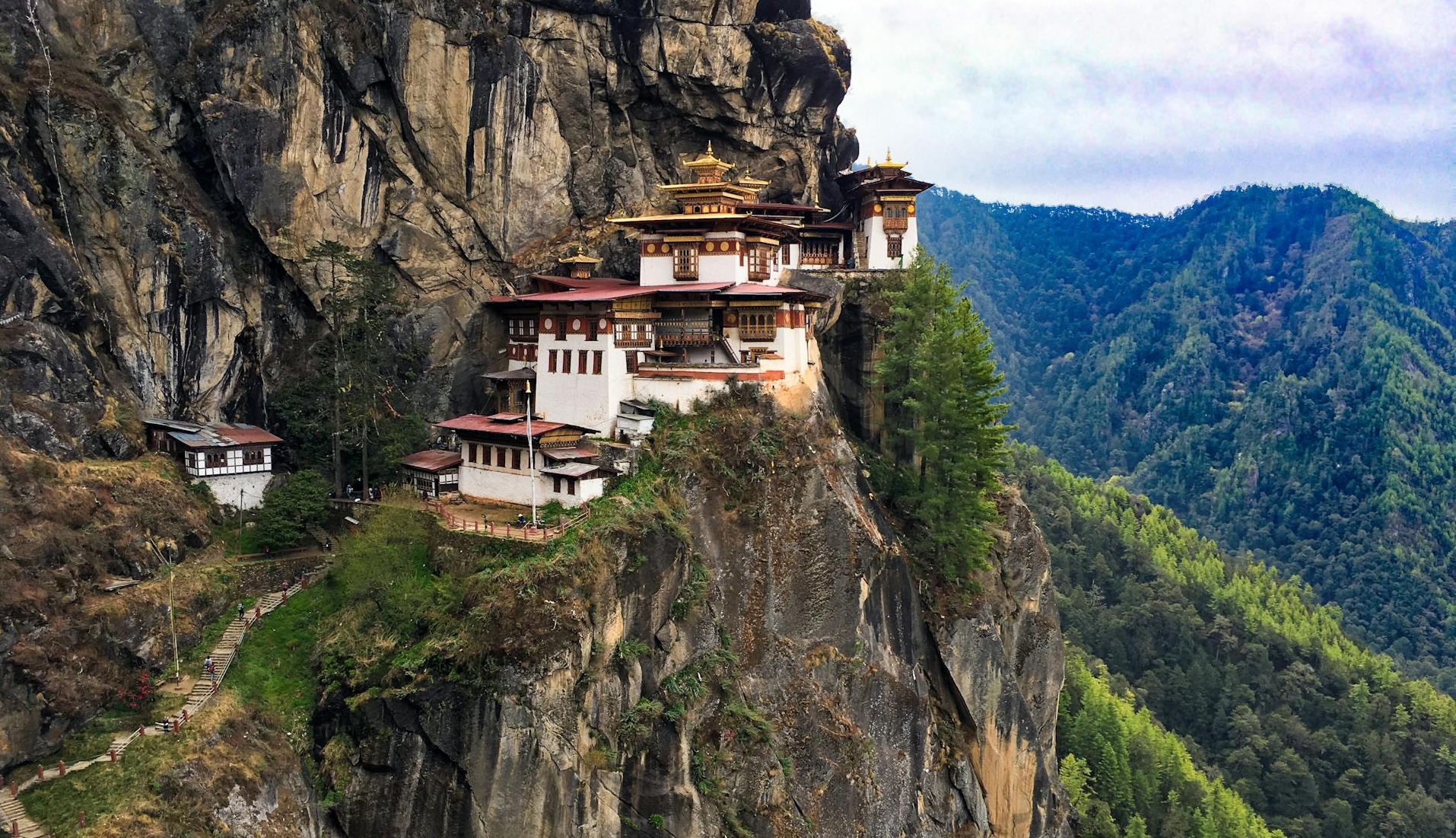
Day 6: Tiger's Nest (Paro Taktsang) hike to ~3,120 m
This is the day people come to Bhutan for. From the Ramthangkha trailhead, the hike to Paro Taktsang is about 4 km one way with 700 to 900 m of elevation gain, and the monastery clings to a granite cliff at roughly 3,120 m. Plan on 2 to 3 hours up and 4 to 5 hours round trip. There is a cafeteria at the halfway point, around 2,950 m, where you should rest and drink. Pace yourself deliberately; this is not a race, and steady walking with regular breaks gets almost everyone there. Because you have spent the week acclimatizing, you arrive at this climb far better prepared than a traveler who flies in and hikes immediately. Turn back if you develop a worsening headache, vomiting, or unsteadiness, which can signal altitude illness rather than ordinary fatigue.
Day 7: Depart Paro
A final quiet morning in the Paro valley before your flight out. If you arrived feeling rough and never fully shook it, make a note of your symptoms and timing for your provider. Altitude effects that resolve on descent are expected; symptoms that linger after you have come down deserve a follow-up conversation.
Health prep for this trip
The health plan for Bhutan is light but specific, and most of it happens before you leave. The biggest lever is altitude, and the structure of this itinerary already handles much of it by keeping sleeping elevations low. The CDC's altitude guidance advises against going directly to a sleeping elevation above about 2,750 m in a single day, and recommends moving sleeping elevation by no more than roughly 500 m per day once above that line. This valley route stays comfortably within those bounds, which is why it is a forgiving introduction to the Himalaya.
Still, the Dochula Pass and the Tiger's Nest both cross above 2,500 m, where the CDC notes acute mountain sickness becomes meaningfully common. For most travelers, gradual pacing is enough. If you have a history of altitude illness, or you compress the itinerary, ask a licensed provider about acetazolamide, which both speeds acclimatization and treats AMS. The CDC describes a low threshold for using it when staged ascent is not feasible. For vaccines, the CDC currently recommends Hepatitis A and Typhoid for most travelers to Bhutan, both food- and water-related, in addition to staying current on routine vaccines like MMR; review the full picture on Wandr's Bhutan travel health guide and book your shots at least a month out. You can plan the altitude meds and a traveler's diarrhea backup together through the Bhutan Tiger's Nest travel-medicine kit.
What to pack
Bhutan's weather swings between valley warmth and pass cold within a single day, so layer. Bring a warm mid-layer and a windproof shell for the Dochula Pass and early mornings, sturdy broken-in hiking shoes for the Tiger's Nest, and a daypack with at least 1.5 to 2 liters of water capacity. Add high-SPF sunscreen and sunglasses, since UV intensifies with elevation, plus a brimmed hat and trekking poles if your knees prefer them.
For the medical kit, carry any prescribed altitude medication, an anti-nausea option for the winding roads, oral rehydration salts, a traveler's diarrhea antibiotic if your provider prescribes one, basic blister care, and your routine personal medications with a few spare days' worth. Keep prescriptions in original labeling. Bhutan's pharmacies are limited outside the main towns, so arrive self-sufficient.
Best time to go and what to avoid
Bhutan has two clear high seasons. Spring, March through May, brings rhododendron bloom and generally stable trekking weather. Autumn, September through November, delivers crisp, clear mountain views once the monsoon clears, and it overlaps with major festivals. Both windows favor the Tiger's Nest hike and clear Himalayan panoramas from Dochula.
Avoid scheduling the trip so tightly that bad weather forces you to skip acclimatization or rush the Tiger's Nest. A single buffer day in Paro covers most weather surprises and protects the part of the plan that protects you.
Cost expectations
Bhutan is a higher-cost destination by design. The government levies a Sustainable Development Fee per traveler per night on top of your accommodation, guiding, and transport, since independent travel is restricted and most visitors book through a licensed operator. That structure bundles a lot of logistics into one price, which simplifies planning but raises the floor. Budget for the fee, in-country guiding and driving, lodging, and your pre-trip clinical visit and travel-medicine kit. The health spend is small relative to the trip and pays for itself the moment altitude or a stomach bug would otherwise derail a day you came a long way to enjoy.
Day-by-day plan
| Day | What you're doing | Health note |
|---|---|---|
| 1 | Arrive Paro, settle at ~2,200 m Land in the Paro valley, visit Rinpung Dzong and the National Museum, walk the riverside. | Treat day one as acclimatization. Hydrate, skip alcohol, and keep exertion light at 2,200 m. |
| 2 | Paro to Thimphu (~2,334 m) Short drive to the capital. Buddha Dordenma, the Memorial Chorten, and an easy city walk. | A small elevation gain. Note any headache, nausea, or poor sleep as early AMS signals. |
| 3 | Thimphu acclimatization hike Hike toward Cheri or Tango monastery (~2,800-3,000 m), then return to sleep low in Thimphu. | Climb high, sleep low. A day hike above the city builds acclimatization without raising your sleeping elevation. |
| 4 | Thimphu to Punakha over Dochula Pass (~3,100 m) Cross the Dochula Pass and its 108 chortens, then descend to warm, low Punakha (~1,250 m) for the Punakha Dzong and Chimi Lhakhang. | The pass is the highest point of the road days, but you descend to sleep low. The switchbacks can trigger nausea; ondansetron helps if you are prone to it. |
| 5 | Punakha back to Paro Return drive over Dochula to Paro. Rest, gear check, and an early night before the big hike. | Hydrate, eat a light dinner, and pre-stage your kit. A rested, well-fueled start lowers your effort on the Tiger's Nest climb. |
| 6 | Tiger's Nest (Paro Taktsang) hike to ~3,120 m The signature day. From the Ramthangkha trailhead it is about 4 km one way with 700-900 m of gain to the monastery. | Pace deliberately, rest at the halfway cafeteria (~2,950 m), and turn back if you develop worsening headache, vomiting, or unsteadiness. |
| 7 | Depart Paro Final valley morning, then fly out of Paro. | If you flew straight in and felt rough, log symptoms for your provider; AMS that lingers past descent deserves follow-up. |
Frequently Asked Questions
Not always. The Tiger's Nest (Paro Taktsang) sits at about 3,120 m, but you hike up and back the same day rather than sleeping there, which lowers the risk of acute mountain sickness. The CDC reports AMS affects roughly 25% of people who sleep above 2,500 m. Most travelers on this valley route sleep below 2,400 m. Many people do fine with gradual pacing alone, but if you are ascending faster than recommended or have a history of altitude sickness, talk with a licensed provider about acetazolamide.
The valleys you sleep in are moderate: Paro is around 2,200 m and Thimphu around 2,334 m. The two points that cross above the 2,500 m AMS threshold are the Dochula Pass at roughly 3,100 m, which you only pass through, and the Tiger's Nest at about 3,120 m, which is a day hike. Punakha, by contrast, sits low at around 1,250 m. Because you sleep low and visit high, this is a gentler altitude profile than a Himalayan trek.
Beyond routine vaccinations such as MMR, the CDC currently recommends Hepatitis A and Typhoid for most travelers to Bhutan, both linked to food and water exposure. Recommendations depend on your health history and exact itinerary, so confirm specifics with a licensed provider at least a month before departure.
Generally not on this route. The CDC notes malaria transmission in Bhutan is limited to rare cases in rural areas below about 1,700 m along the southern border with India, and recommends mosquito-bite precautions rather than preventive pills for most travelers. The Paro, Thimphu, Punakha, and Tiger's Nest circuit sits outside that risk zone. Confirm your specific plans with a clinician if you are adding southern lowland districts.
Spring (March to May) and autumn (September to November) generally offer the clearest skies and the most reliable hiking weather. Spring brings rhododendron bloom; autumn brings crisp mountain views after the monsoon. The summer monsoon (roughly June to August) makes trails slick and views hazy, and winter is cold with possible snow on the passes. Conditions vary year to year, so build in a buffer day for weather.
The hike is about 4 km each way with 700 to 900 m of elevation gain, typically 2 to 3 hours up and 4 to 5 hours round trip. It is strenuous but non-technical, and there is a cafeteria roughly halfway at about 2,950 m where you can rest. Train with hills or stairs beforehand, pace yourself, and use the acclimatization built into the first days of this itinerary. Most reasonably active travelers complete it; turn back if altitude symptoms worsen.
The Thimphu to Punakha drive crosses the Dochula Pass on switchbacks that can provoke motion-related nausea. Sitting in the front, looking at the horizon, and keeping the car ventilated all help. If you are prone to nausea or vomiting, ondansetron can be useful, and a clinician can advise on timing. Discuss options before you travel rather than improvising on the road.
Stick to bottled or treated water and well-cooked food to lower your risk. If you develop traveler's diarrhea, prioritize oral rehydration. For moderate to severe cases, the CDC supports a short course of an appropriate antibiotic; Wandr's protocol uses azithromycin 500 mg once daily for 3 days rather than older regimens. Speak with a provider about what fits your history, and seek care for high fever, bloody stools, or symptoms that do not improve.
It can be, as a contingency. Acetazolamide both speeds acclimatization and helps treat acute mountain sickness, and the CDC notes a low threshold for using it when gradual ascent is not feasible. On this valley itinerary many travelers never need it, but carrying a supply means you are prepared if you ascend faster than planned or extend to higher Himalayan routes. Use it only under guidance from a licensed provider.
Alec Freling, MD is a board-certified emergency medicine physician and co-founder of Wandr Health with ER experience treating returning travelers.